Showing posts with label Castle Rock. Show all posts

Wednesday, May 26, 2021

Santa Fe Trail Days


Photo Credit:  Larry D. Fenwick

What is it about human nature that sometimes causes us to be excited about distant places, while local sites and events inspire little more than a yawn?  I suspect all of us are sometimes guilty of that attitude.  I know that I am, and that is a shame.

Photo Credit: Lyn Fenwick

One of the things I have tried to do with this blog is to share the sights and history of Kansas, from the towering rock formations of northwestern Kansas to the nearly forgotten Beecher church.  I have urged readers not to hurry past road signs directing travelers to local features, intending to visit another time, if not ignoring them completely.

Some of these Kansas treasures are natural wonders, like Castle Rock, pictured at left.  Others are rich in history, like the Beecher church, that reminds us of the New Englanders that left their home to come to Kansas so that they could join other settlers in voting for Kansas to join the Union as a Free State.

Photo Credit:  Lyn Fenwick


This weekend, from Thursday, May 27th, to Sunday, May 30th, the Larned, Kansas Area Chamber is hosting its 29th Annual Santa Fe Trail Days.  From Horse Drawn Carriage rides on Thursday to a Community Worship Service on Sunday, with an amazing range of events throughout those 4 days, the event calendar is crowded with activities.  You can go to MORE  INFORMATION @ WWW.SANTAFETRAILDAYS.ORG to discover more activities.

One of those activities, at 2 p.m. on Saturday, May 29th, is a power point talk and book signing by me, particularly including references to Larned that appear in  "Prairie Bachelor, The Story of a Kansas Homesteader and the Populist Movement."   

I will be speaking in several local communities in the following weeks, and for each location, I will include different information from "Prairie Bachelor," including various images in the power point presentation and readings related to the community in which I am speaking.  If you should choose to attend more than one, there will be new material in each book talk.

Photo Credit:  Larry D. Fenwick
Some of you may read this blog too late for the 2021 Trail Days events, but it will not be too late to take advantage of visiting the Santa Fe Trail Center or Fort Larned, both wonderful places to enjoy and to share with family and visitors, especially when you are hosting guests from other places.  It is a great opportunity to show off our home state.

Maybe I will see some of you at the Santa Fe Trail Center on May 29, 2021, or maybe I will see you at a different book signing, but don't forget that Kansas has many wonderful places to visit.  Thank you to everyone who is being so supportive of my book, not only local readers but readers across America and internationally.  Isaac Werner may have been a forgotten man for many decades, but he isn't forgotten now! 


Thursday, July 20, 2017

Sedimentary Formations


Natural Bridge near Sun City before demolition
Some of you who are long-time followers of this blog may remember the blogs about the Natural Bridge near Sun City, KS, and you may also remember the blogs about Isaac Werner's potato-selling trips to Sun City, during which he ruminated about the unusual terrain and rock formations.

The photograph at right clearly shows the layering of sedimentary rock in the Natural Bridge near Sun City taken prior to its destruction.  It also shows how water gradually cut an opening in the rock to create the bridge.

Photo credit:  Moondigger
Many beautiful formations can be found in the United States.  The picture at left, taken from below with the camera aimed skyward "Inside Lower Antelope Canyon" by Moondigger, shows the effect of erosion by wind and water that has exposed the elegant sculpturing of layers of sandstone.

In Southwestern Utah a more rugged example of Sedimentary Formations consisting of siltstones and limestones from the Middle Triassic Period illustrates another means of layering in sedimentary Formations.

Viewed by us but not my photograph
Others of you who follow the blog regularly will also remember my posting of photographs taken of Castle Rock and surrounding outcroppings in that area of northwestern Kansas.

My fascination with sedimentary formations caused me to see one particular circumstance in a geological manner, rather than observing it for what is actually was.

Castle Rock in Kansas
A Kansas "mountain range"
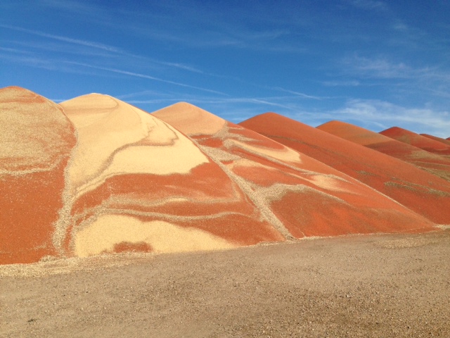
Use your imagination to picture the "mountain range" at right as a sedimentary formation, laid down layer by layer.  That is exactly what I did for a split second as we drove by a Kansas field.  Of course, what I saw was not a mountain range built up layer by layer over eons but rather piles of grain unloaded side-by-side by a Kansas farmer who must have found himself lacking granary storage space.

While it may not have been a mountain range, it was beautiful and offered an interesting comparison of how different materials deposited on top of each other over many eons created the sedimentary rock formations we see today in such places as those pictured above.

The photograph at right shows the grain auger used to transfer the grain from the truck that brought it to the site onto the cleared area on which the grain is being temporarily stored.

The last image shows more closely the layering resulting as the auger deposits the grain on the pile, truck load by truck load.

Beauty is all around us, and with a little imagination, what we see can transport us to imagined places--a wind-shaped canyon, a far-away desert, a distant planet!

Remember, you can enlarge the images by clicking on them.


Thursday, August 27, 2015

Castle Rock

Old photograph of Castle Rock
Returning from a niece's recent wedding in Colorado, we spotted a sign directing travelers to Castle Rock.  How many times do all of us take for granted interesting places and events in our general area, thinking we will visit them another time or just taking them for granted because they are nearby?  We had heard about Castle Rock, and we must have passed that sign other times when we were traveling the interstate, but we had hurried by without noticing.  Perhaps like those other times when we kept driving, we were tired and eager to get home, but when my husband asked, "Shall we go see it?" I replied, "Let's do it!"  We left the paved road behind and were on our way

Near Castle Rock, credit Lyn Fenwick
The region in which Castle Rock is located is known as the Smoky Hills of Kansas, and the outcroppings of limestone rocks in what is primarily pasture land present a very different terrain from the sandy loam fields around Isaac Werner's old homestead.  After driving 14 miles we saw a small sign directing us to turn left toward Castle Rock, and when we spotted the outcropping of limestone rock pictured at right, we assumed we were getting close.

Castle Rock is located on private land, and there are no large billboards to direct visitors.  Eventually we saw another small sign indicating we needed to turn left again, and we pulled onto a smaller road which was barely more than what a cattleman might use to get back to his pasture to tend his livestock.  At last we saw two parked cars, and we pulled alongside and walked up a bluff.  Looking off to the north, we got our first glimpse of Castle Rock.
Our first glimpse of Castle Rock, credit Larry Fenwick

We could see roads around Castle Rock, so while I paused to take photographs, my husband went exploring to find the access to those roads.  Castle Rock is a limestone formation weathered by wind and water to create what reminded people of a castle and resulted in its name.  Obviously that weathering continues, and the effects can be exacerbated by people climbing on the rocks.  If you study my photographs closely and compare them with the older photograph at the top of the blog, you may see that one of the castle-like shapes at the top of a pillar is gone, having fallen after a thunderstorm in 2001, perhaps having been weakened by climbers.

Photo credit:  Lyn Fenwick
Castle Rock is located north and west of Isaac Werner's claim, too far for it to be likely that he ever saw it.  However, many early settlers did, for it was a landmark on the Butterfield Overland Dispatch route (also known as the Overland Trail). 

Imagine travelers crossing the prairie without the paved roads and signage that we have.  Well-traveled routes surely had wheel ruts to help guide them, but those may have been hidden by the prairie grass or faint in rocky soil.  Natural landmarks were their guides, and the towering Castle Rock must have been a welcome sight to many travelers.

Pond Creek Station near Wallace, KS
Even more welcoming may have been the  stations built along the stagecoach route.  Today one of the Butterfield Overland Dispatch stage company buildings has been preserved, not far from its original location.  Located on US Highway 40 in Wallace County, KS, the station was built in 1865.  It survived being moved in 1871 and 1898, finally being returned to near its original location.  The restoration still retains bullet holes from Indian attacks.

We were glad we took the time to deviate from our route in order to see Castle Rock.  Standing on the bluff, we could see for miles, and it was easy to imagine what a courageous undertaking it must have been for the early settlers to leave family and familiar settings behind and strike out for a new life in faraway places they knew only from often exaggerated descriptions in newspapers and promotional flyers.  For many, perhaps most of them, it meant saying good-bye for the last time to family members and friends.

Photo credit:  Lyn Fenwick
We were glad we added a few hours to our journey in order to see Castle Rock and to reflect on the early pioneers like Isaac B. Werner and some of our own family members who made the journey West.  But, we were also glad to get back to the interstate and make the journey to our home in air-conditioned comfort and in time to sleep comfortably in our own bed!