Showing posts with label Sun City (KS). Show all posts

Thursday, June 13, 2019

Isaac Werner Visits Cullison, Part 3

Wagon displayed in Stafford County (KS) Museum
Having been successful marketing his potatoes further south of his community, Isaac Werner planned his last trip before winter.  The cold weather required special preparations for his trip, which began October 24, 1887.  "By 9 a.m. I got done choring & off with my load of potatoes for Stringfield's [the local blacksmith].  Got mares shod in front & off for Cullison.  There by 2 p.m. & cold raw NE air & cloudy, about bordering on snow.  Disagreeable cold to be out unless extra warm dressed to sit on wagon."

Eager to resume his trip in daylight, before temperatures dropped with the setting sun, "...by 3 left Cullison & by dusk turned in at J.P. Chinn's ranch 7 miles N. of Sun City.  Chilling night air sure, covered my potatoes some extra."

Isaac "found Chinns a clever family."  In the 1890 Federal Census, it appears that John P. and Joanna Chinn had both been born in Kentucky.  They had four sons--Isaac L. (born about 1853), Garrett C. (born about 1855), John T. (born about 1857), and Eddie D. (born about 1863), all of whom were born in Iowa, indicating that the couple had not come directly from the land of their births to Kansas.  By the 1900 Federal Census, J.P. Chinn is a widower living by himself in Pratt, Kansas.

Bachelor Isaac, living alone as he did, enjoyed the opportunity to visit with people he found interesting, and after his night's rest, the following morning had "cleared off and moderating into pleasant day," so he lingered for "a lengthy morning talk with Mr. & Mrs. Chinn," delaying his start until "by 10 I got started & by noon down to Sun City, good roads and agreeable weather."  Although Isaac had taken the precaution of covering his potatoes "some extra" the night before, a "few got frost bitten on top layer under 3 thicknesses of wagon cover." 

Slicker Ad from St. John County Capital newspaper
Isaac was disappointed when, unlike the market for his previous marketing trips to Sun City, "potato market somewhat dull--money so scarce.  Finally I sold 5 bushels at Hotel and 16 1/2 to dry goods store (Dougles), all at a dollar a bushel."  He did a "a little trading & by 4 ready to start back, & after dusk & moonlight by 8 to Spring Vale.  Staied [sic] there over night in feed stable.  Thirty-five cents to hay and stable."  As part of my research for the manuscript, my husband and I traced Isaac's route for this trip, but our search for Spring Vale found no remaining trace.  

The next morning dawned "fair & pleasant," and Isaac went to Wellsford to get "some needed harness trimmings & collar."  Unfortunately, Isaac had forgotten his new slicker and had to backtrack to Spring Vale to retrieve it.  That done, Isaac headed to Cullison to feed his team.  After giving his team a short rest, he headed to Pratt, making that day's journey about 40 miles.

Next week's blog will conclude Isaac's potato marketing trip as he does some shopping in Pratt and pauses for a visit with a neighbor before returning home.

Thursday, June 6, 2019

Isaac Werner Visits Cullison, Part 2

James B. Cullison moved on to Oklahoma with his family, but the town named for him began to grow.  (You may visit last week's blog to learn about the young family's arrival on the prairie and the roots of Cullison.)  By 1887, the new town was thriving, and Isaac B. Werner  decided to travel south of his claims in search of markets for his potatoes.  On July 21, 1887 he loaded 4 bushels of a neighbor's corn and 9 bushels of his own potatoes "...and by 2 p.m. got started off & by sun down in Cullison, staied [sic] at feed stable."

When Isaac arose the next morning he left Cullison for "...Spring Valley with my potatoes and sold same to Bridge camp at 87 1/2 cents a bushel."  The camp he mentions was an encampment of rail road workers building a bridge for the rails headed west.  He passed through Cullison on his way home, but the next morning he took a load of potatoes north to St. John.

On July 12, 1887, he decided to travel further south in search of potato markets, and although he passed through Cullison, he continued in the dark to stay with Judge Purdy overnight.  He was headed for Sun City, and "...by 11 got in there, among winding hollows & green trees."  Isaac commented on the corn, only fit for fodder, and the dry crops.  

Isaac's library contained books of all sorts, and his guesses about the terrain he was passing through  suggests his knowledge of geology.  "[C]urious country around there, once a flat country but gullies started and washed by ages & frosts crumpling projecting rock flatten bluff sides down to gentle sloping & now green grass covered."  In Sun City he got a dollar and more for his potatoes and fifty cents for his corn, and with storm clouds coming from the west, he returned to Cullison for the night.

Near the end of August, Isaac made another trip to Cullison, again spending the night in the feed stable.  Given the recent history of severe storms in the Greensburg area, I read this passage written in Isaac's journal on August 30, 1887, with particular interest:  "Trifling shower working from NW against light-sprinkling clouds coming up from S tending to sprinkle from both directions, but the NW movement conquered finally, some lightning & thunder & towards 4 p.m. some of steadiest showering for a good hour's duration seldom witnessed; seemed like 6" of water fell, ground flowing & covered, the upper part of shower going S and lower part blown by on strong wind from S at wind of almost cyclonic for short spell tearing down some buildings and several at Greensburg.  I staied [sic] over night in Metropolitan feed stable, its floor flooded 6".

Despite the conditions and the hard pull for the horses, he went to Greensburg the next morning and "by 4 p.m. soon disposed of my 18 bushel corn at 45 cents and ten and a half bushel potatoes at $1.25," calling Greensburg "a live town, business booming on all sides."  He headed east for 12 miles, spending the night in Haviland to let the roads dry over night for easier travel.

Of particular interest to history is that when he reach Cullison the next morning, the "...Rock Island R.R. track entered town by noon"

Next week I will continue with Isaac's return to Cullison in October. 

Thursday, July 20, 2017

Sedimentary Formations


Natural Bridge near Sun City before demolition
Some of you who are long-time followers of this blog may remember the blogs about the Natural Bridge near Sun City, KS, and you may also remember the blogs about Isaac Werner's potato-selling trips to Sun City, during which he ruminated about the unusual terrain and rock formations.

The photograph at right clearly shows the layering of sedimentary rock in the Natural Bridge near Sun City taken prior to its destruction.  It also shows how water gradually cut an opening in the rock to create the bridge.

Photo credit:  Moondigger
Many beautiful formations can be found in the United States.  The picture at left, taken from below with the camera aimed skyward "Inside Lower Antelope Canyon" by Moondigger, shows the effect of erosion by wind and water that has exposed the elegant sculpturing of layers of sandstone.

In Southwestern Utah a more rugged example of Sedimentary Formations consisting of siltstones and limestones from the Middle Triassic Period illustrates another means of layering in sedimentary Formations.

Viewed by us but not my photograph
Others of you who follow the blog regularly will also remember my posting of photographs taken of Castle Rock and surrounding outcroppings in that area of northwestern Kansas.

My fascination with sedimentary formations caused me to see one particular circumstance in a geological manner, rather than observing it for what is actually was.

Castle Rock in Kansas
A Kansas "mountain range"
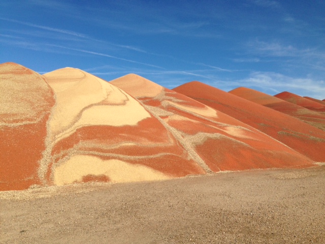
Use your imagination to picture the "mountain range" at right as a sedimentary formation, laid down layer by layer.  That is exactly what I did for a split second as we drove by a Kansas field.  Of course, what I saw was not a mountain range built up layer by layer over eons but rather piles of grain unloaded side-by-side by a Kansas farmer who must have found himself lacking granary storage space.

While it may not have been a mountain range, it was beautiful and offered an interesting comparison of how different materials deposited on top of each other over many eons created the sedimentary rock formations we see today in such places as those pictured above.

The photograph at right shows the grain auger used to transfer the grain from the truck that brought it to the site onto the cleared area on which the grain is being temporarily stored.

The last image shows more closely the layering resulting as the auger deposits the grain on the pile, truck load by truck load.

Beauty is all around us, and with a little imagination, what we see can transport us to imagined places--a wind-shaped canyon, a far-away desert, a distant planet!

Remember, you can enlarge the images by clicking on them.


Thursday, September 4, 2014

The Natural Bridge, Part II

Natural Bridge near Sun City, Kansas
Last week's blog, "The Natural Bridge,"   (archives, 8-28-2014), about artist, Birger Sandzen's paintings and prints drew many visitors to the blog.  Some of those visitors left comments, a few at the blog, but many more on face book.  One of those comments was left by Janice Smith Urban with a link to a wonderful website containing many photographs.  The photographs used in this blog are from the Collection of Brenda McLain, courtesy of Kim Fowles, with post card images collected by Kim Fowles, together with images from the Kansas Geological Survey.  I recommend a visit to that website, http://www.rootsweb.ancestry.com/~ksbarber/natbridge.html where specific photo credits are shown and additional photographs may be viewed.  My thanks to Janice, who led me to the site, and to the many others who left comments.

Taken by Stan Roth in 1961, KsGeoSurvey
The face book comments described visits by many people when they were children, and the wonderful old photographs document visits far earlier, judging from the clothing and an old automobile in one image.  Look closely at the photo above to see the three young women in their long, white summer dresses which would have been the fashion from the early 1900s.

The photograph at left was taken in 1961, showing very different dress of the men in the picture.  Compare the condition of the rocks in the two photographs, and notice how the cracks have become more apparent.  The bridge collapsed shortly after the 1961 photograph was taken.

Last week's post included excerpts from an interview published Dec. 5, 1940, in which Sandzen expressed his concern about the stability of the bridge.  He urged the importance of immediate preservation efforts, and, in fact, there were efforts taken for the state to acquire the property as a historical site.  An article in the Barber County Index, dated Feb. 20, 1942, describes passage by the Kansas House, which was sent to the Senate as a joint resolution, directing the Kansas Fish and Game Commission to acquire the Natural Bridge to be supervised and promoted by the state.  Unfortunately, the resolution required acquiring the area described at no cost, and the property remained in private hands.

From Fowles Collection
A detailed description of the bridge by Prof. F. W. Cragin appeared in the 1912 Kansas:  a cyclopedia of state history, Vol. II, p. 336, a copy of which is in the collection of the Pratt Historical Museum.  "The bridge spans the canyon of the creek, here about 55 feet from wall to wall.  The height of the bridge above the bed of the creek is at the highest point 47 feet, at lowest 31, and at middle 38.  The width of the bridge at the middle is 35 feet.  The upper surface of the bridge declines toward the downstream side, but not so much that a wagon drawn by a steady team could not be driven across it."

Children wading under the Natural Bridge
Former Pratt resident Chuck Renner described in a face book comment the creek as being about 4' wide and 2' deep when he was a boy and his father allowed Chuck and his siblings to swim in the water.  Others remembered a dry creek bed, or no more than a trickle of water.

Prof. Cragin's description reads:  "The relief of the vicinity seems to indicate that at a geologically recent time Bear creek here flowed to the east of its present course, and that its waters, becoming partially diverted by an incipient cave, enlarged the latter, and finally were entirely stolen by it, the cave at length collapsing, save at the portion now constituting the natural bridge."  Since present memories of the amount of water in Bear Creek when they visited as children vary, perhaps the amount of rainfall explains the differences.  However, there was certainly water in Bear Creek when the children in the photograph above visited.  (Clothing would indicate the early 1900s.)

Entrance to Havard's Cave
Filley Docent Gary Curtis, upon seeing the Sandzen painting of The Bridge in the "Kansas Ties" exhibition at the Filley Art Museum, described being encouraged by my older brother Clark to enter a cave where Gary became stuck in a narrow passage.  In a 2005 exchange of e-mails between Kim Fowles and David Massey, he described high school boys entering Havard's Cave.  "The tough part was the entrance as you had to lower yourself down into a sink-hole, finally get yourself flat on your stomach and wiggle yourself in for several feet, then it would open up and finally you could stand up.  It was fairly spacious and [I] don't remember how big it was now, but I'm sure it was a lot less than I remember it.  The first fellow that entered it had to have had nerves of steel as there is very little wiggle room at the beginning and its not easy to wiggle backwards if you met something that did not welcome you."  Massey's description sounds as if Gary might have remembered that tight passage into Havard's Cave.  (The photo of Havard's Cave is from the collection of Elizabeth Covington Hoagland, via Kim Hoagland Fowles.)

As for the 'something that did not welcome you,' Chuck Renner may have offered a clue about what that could have been.  His face book comment described a family visit when his sister jumped from the car ahead of the rest of the family and nearly stumbled into a pit with at least twenty rattlesnakes in it!  Chuck had never seen so many rattlesnakes at one time, and he has never forgotten what he saw that day.  Lee Massey, in the 2005 exchange of e-mails, described a cave that ran from one side of the bridge to the other.  "It was exciting to go thru," she wrote. "I was always afraid of Rattlesnakes.  It was always cool.  There was a ledge along one wall and I was afraid snakes would like it."

Collapsed Natural Bridge, KsGeoSurvey
I have saved the saddest photograph for the close of this blog.  The danger of a collapse from natural causes had long been known.  Perhaps that is what occurred.  However, it is suggested by others that the bridge was dynamited because of the liability it presented.  What is obvious from this photograph is that the place remembered fondly by many people living in this area is gone.  There is no question that trespassing was frequent and risks were taken.  The photograph taken in 1961 shows how the cracks had enlarged from what appeared in earlier photographs.  Liability concerns were reasonable, however tragic the destruction of a beautiful natural wonder loved by so many people and worthy of designation as a State Historical Site may have been if, in fact, it was dynamited.  

Jerry Ferrin may have been one of the last to visit the bridge and to crawl through a small tunnel under the bridge, a tunnel Nancy Smith has early home movies of her father and her grandparents with others "coming out of it, shaking the dirt off, laughing and having a good time!"  In the 2005 exchange of e-mails, Jerry wrote, "Dad had heard the natural bridge was to be destroyed, and took us to see it soon before that was done."  

Sadly, those of us who can remember visiting the bridge now have gray in our hair, and family visits can no longer wade under the bridge and crawl through the caves.  However, all of us can visit the Vernon Filley Art Museum now through November 30, 2014 to see Birger Sandzen's painting of The Bridge, on loan from the Birger Sandzen Memorial Gallery in Lindsborg, KS.  Visit last week's blog for more information.


(Remember, you can click on the images to enlarge them.  Be sure to add comments to this blog if you have memories to share.)

Thursday, August 28, 2014

The Natural Bridge

Near Sun City, Kansas
In the autumn of 1887, Isaac Werner made three trips to Sun City, Kansas to market potatoes.  The market for potatoes nearer his homestead was glutted, but the soil around Sun City did not encourage farmers to raise potatoes.  Of the rugged terrain, Isaac wrote "curious country around here."  To read more about Isaac's trips, visit "The Trip to Sun City" in the blog archives at 2-20-2014.

The photograph at right gives some idea of the rugged terrain; however, one parcel of land was so rocky and rough that people called it "Hell's Half Acre."  The Barber County Index published an interview on October 6, 1927 of an early settler from Kentucky who had come to Barber County to claim land.  During that interview, Green Adams explained why he had chosen such rugged land.  "The first of March 1873 I came to Barber County.  A great many people wonder why I came to Barber county when I passed over so much good land further east.  The reason was because there was plenty of timber and water in Barber County.  As I came from a heavily timbered country I didn't think I could get along without timber."

The land known as "Hell's Half Acre" remained in the Adams family until about 1958, when family member, Bruce Adams, sold the land near Sun City and moved into Pratt.  By that time, many people in the surrounding region knew about a natural bridge and some caves located on the land.  It was not unusual for families to travel there for picnics.  Schools even brought buses of children to visit the natural bridge.

I was one of those school children.  Most of us had never seen a natural bridge, and to our innocent eyes this was about as exciting as a visit to a National Park like Arches or the Grand Canyon.  The existence of this natural wonder spread as far as Lindsborg, Kansas, where artist Birger Sandzen learned of its existence.  He traveled to the site and used the bridge as the subject for his art.  Sandzen's painting is the centerpiece for the special exhibit, "Kansas Ties," currently at the Vernon Filley Art Museum through November 30, 2014.

Sandzen's oil painting  "The Bridge, Pratt, Ks," 1941
A recent visitor to the museum shared the website for the December 5, 1940 Johnson (Kansas) Pioneer, where on page 10 an interview with Birger Sandzen is reported.  Sandzen explained that he had been doing some sketching of the natural bridge, and he urged the importance of stabilizing the bridge to preserve its beauty.  He had observed that rains were weakening the rocks, endangering its collapse.  Sandzen praised the beauty of the area, saying it reminded him of the Grand Canyon.

At the Opening of the "Kansas Ties" exhibition at the Filley on Friday evening, August 22, 2014, many visitors described their own visits as children to the area, sharing clear memories of the wonderous natural bridge they had enjoyed.  Sadly, the bridge no longer arches across the creek bed below.  Although many of us clearly remember the bridge, no one recalled the amount of water depicted in Sandzen's painting.  In fact, several believed the bridge spanned a dry creek bed.

"Kansas Ties" is on loan from the Birger Sandzen Memorial Gallery in Lindsborg, Kansas, and along with Sandzen's work, the work of other artists with Kansas connections, as well as connections as friends, fellow artists, and students of Sandzen, are exhibited.  Perhaps best known among those artists is John Steuart Curry, famous  for his mural in the Kansas State Capitol in Topeka with its depiction of abolishinist John Brown.  Curry was included with Missouri artist Thomas Hart Benton and Iowa artist Grant Wood as the three leading Regional Painters of the early 20th Century.

While you can no longer visit the natural bridge in Hell's Half Acre, you can visit the Vernon Filley Art Museum to see its depiction in an oil painting and to learn more about the role of Kansas artists during this period.  The "Kansas Ties" exhibition may be viewed through November 30th, and you may even want to join one of the 1st Saturday Docent tours conducted the first Saturday of every month for visitors who come to the Filley at 1:30 p.m..  Visit http://www.vernonfilleyartmuseum.com for more details.

Thursday, February 20, 2014

The Trip to Sun City

Downtown Sun City
 When a friend read about a fun bar and restaurant called Buster's in Sun City, Kansas, she suggested that my husband and I join her and her husband for dinner on Halloween week-end.  She had heard that patrons were encouraged to costume for the occasion, but we settled for boots and jeans.  We fit in perfectly with the other ranchers and farmers, although there were a few people in costume.

Opposite side of the downtown street
We accepted the invitation not only because we looked forward to an evening with our friends, but also because I was eager to see Sun City.  First, I remembered school bus trips to see the caves and natural bridge nearby.  Second, I wanted to see the old town where Isaac had traveled by wagon to sell potatoes.  Unfortunately, we were delayed in starting the drive (because my friend had hit a deer on their way to our house with her brand new pickup).  By the time we reached Sun City it was too dark to see very much except the well-lighted restaurant and a group of people gathered around a fire nearby to keep warm on the chilly evening.

A few days later, my husband and I happened to be nearby and detoured to see Sun City in the daylight.  The photographs accompanying this blog were taken that day.

Terrain near Sun City
As Isaac's reputation for raising quality potatoes spread, and awareness that he kept part of his crop in his cellar to use as seed potatoes became known, he developed a market in his neighborhood.  He realized that selling seed potatoes in the spring might provide competitors for his own potatoes when they were harvested later, but the cash received in the spring was needed.  As he had anticipated, at harvest the neighbors had their own potato plots and did not buy his potatoes.  Even the markets in towns were glutted.  Consequently, he had to load his potatoes into his wagon and travel to areas where potatoes were not grown.  That was how Sun City became a marketing destination.

The site where Spring Vale was located
Isaac had never traveled to that region of the country, and he described the terrain in his journal:  "Curious country around here, once a flat country but gullies started & washed by ages & frosts crumbling projecting rock flattened bluff sides down to gentle sloping & now green grass covered."  His first trip started at 3 a.m. when he arose to grease his wagon and then went to Eggleston's place to borrow a mule to hitch up with Dolly.  He spent the night at Judge Purdy's place "22 miles south of Cullison" and continued to Sun City the next morning.  He reached his destination by 11 a.m. and sold his potatoes by noon for $1 to $1.25 a bushel.  He started home, traveling through Spring Vale and Turkey Creek Mills, and spending the night in Cullison.  

Turkey Creek
In October, Isaac made another trip to Sun City, stopping this time for an overnight stay at J.P. Chinn's ranch.  The weather was colder than his first trip, and despite covering his potatoes, a few were frost bitten.  He lingered to visit with the Chinns the next morning, finding them "a clever family," but he reached Sun City by 11, disappointed to find the potato market "somewhat dull...money so scarce, finally I sold 5 bushels at Hotel & 16 1/2 to dry goods store (Douglas) all at 1.00 for bushel = $21.50"  

Isaac made his last potato trip to Sun City in early November, selling his entire load of 25 bushels to "one store W. of the Post Office, at 95 cents."  

During our visit I asked about the old hotel and was told it had been torn down when the fire station was built.  I didn't see any building that I could identify as dating back to 1887 when Isaac made his marketing trips, but I did photograph some interesting old buildings.  We went out of our way to drive through Spring Vale, where Isaac had stopped for the night on his October return home, staying overnight in the feed stable.  He stabled Dolly and the mule there, paying 35 cents, including hay, and he spent the night in the stable with them.  There are no longer any buildings.
One of the curving, unpaved roads we traveled

We had passed by Turkey Creek Mills along the way.  It is now a private club.

Although we left paving to explore the country through which Isaac traveled by wagon, we always had the benefit of graded roads.  We found it hard to imagine Isaac's trips with a mare and a mule pulling a wooden wagon loaded with 25 bushels of potatoes through the irregular terrain.